")
The map featured in the video is falsified. StopFake did not find the images shown in the video in the original historical map of Ukraine published by the Kartohrafiya publishing house.
A video with an alleged Ukrainian educational map for 11th graders is actively circulating online, in which, a voice-over assures, a number of regions, including Kherson, Zaporizhzhya, Kharkiv, Donetsk, Luhansk, as well as Lviv and Zakarpattia, are nowhere to be seen. In the video, the man unfolds the map, where one can see that the state border of Ukraine is drawn incorrectly. “This is the new reality!” says a male voice behind the camera.
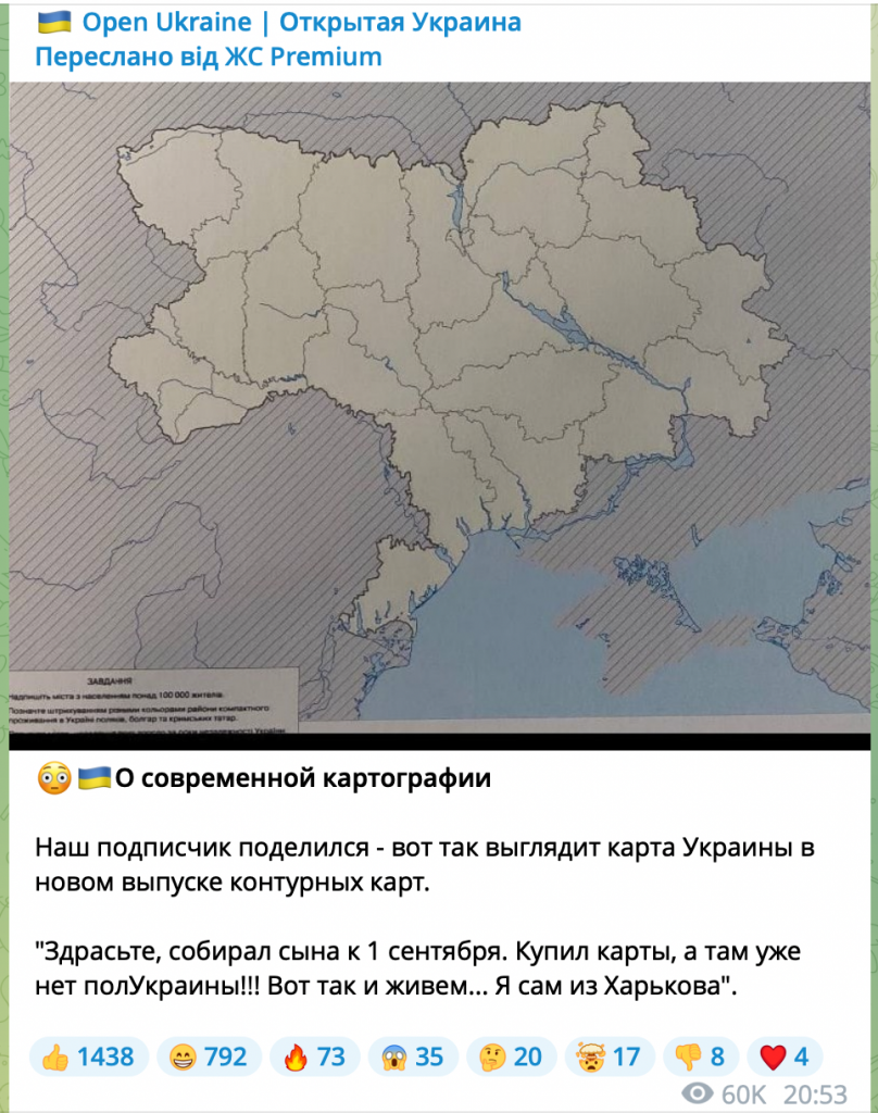
Anonymous pro-Russian Telegram channels also circulated a photo of one of the maps from this edition, which was allegedly sent to the authors by their subscribers. The posts claim that the new edition of the maps no longer include “half of Ukraine”.
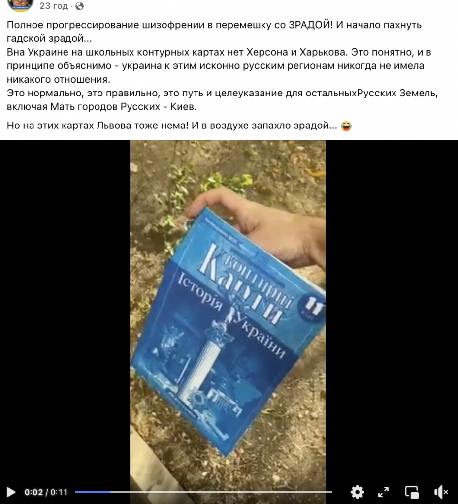
What is shown in the video is an edition of educational outline maps on the history of Ukraine for the 11th grade. These maps by the Kartohrafiya publishing house are recommended for use in schools by the Ukrainian Education Ministry and are among the most popular learning materials in Ukraine.
In 2022, Kartohrafiya research and production enterprise actually did print a new edition of history of Ukraine maps for the 11th grade under ISBN (universal identification number assigned to the book) 978-966-946-460-6. With this number, 2022 outline maps are easy to find and identify among other maps.
StopFake visited the Kartohrafiya publishing shop, where the consultant assured that the new edition is no different from last year’s. After reviewing the latest edition of the mentioned outline map, it is clear that the video circulating online is fake. In the original outline map, which is issued under ISBN 978-966-946-460-6, StopFake did not find the images shown in the video, or those on which the Ukrainian state border is drawn incorrectly.
The image of an “outline map” circulating online has an inscription: “Task: write down the cities with a population of more than 100,000; mark the areas where Poles, Bulgarians and Crimean Tatars reside compactly in Ukraine with different colors”. The original edition has an outline map with the same task, but it looks completely different.
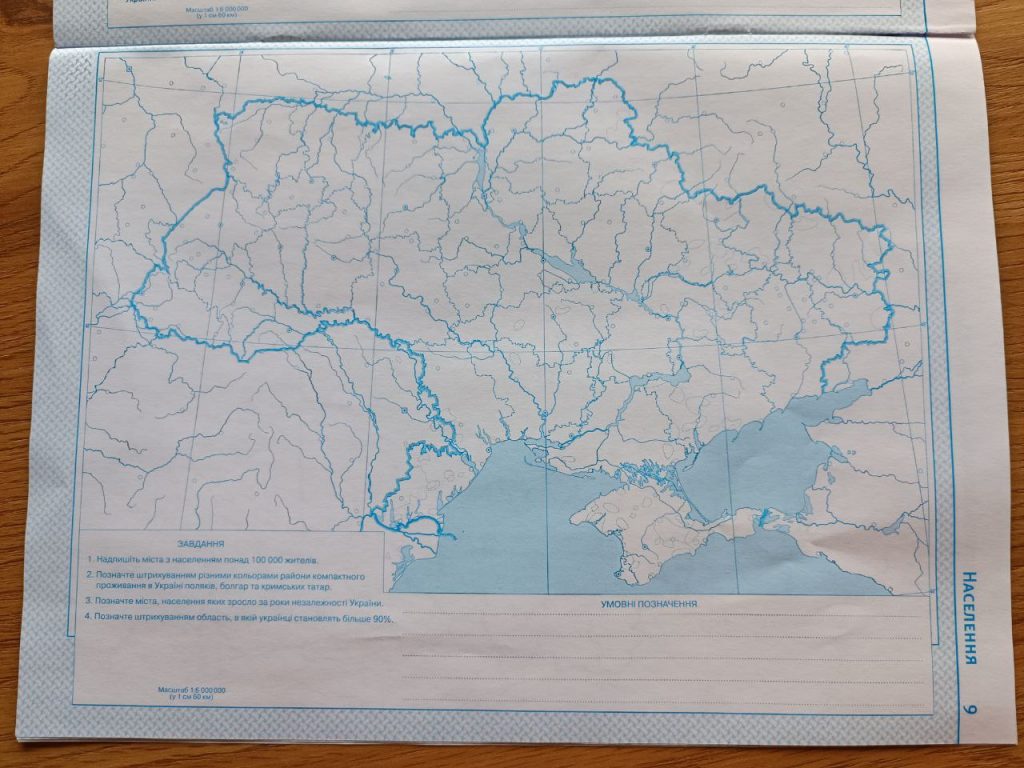
Several other details also indicate that we are dealing with a fake. In the original outline map (2022 and earlier editions) you can see that each map has its own title and each page is numbered. In particular, the map, which was deliberately redacted, is called “Population” in the original edition. The fake edition has neither the name nor the page number. I
It is not difficult to fake this product, because an electronic version of this outline map can be found online. Most likely, someone edited individual pages of the outline map, printed and pasted them into the original edition.
It is worth noting that not only the Ukrainian regions temporarily occupied by Russia, but also part of western Ukraine are missing from the fake map. This detail fits into the Kremlin’s general narrative that Ukraine is about to be divided. In particular, StopFake has repeatedly refuted disinformation about Poland allegedly planning to occupy western Ukraine.


